Parts of Mississippi brace for heavy winds, rainfall from tropical storm in Gulf
Published 9:23 am Monday, September 9, 2024
Mississippi residents are on alert as tropical activity in the Gulf of Mexico ramps up after a quiet start to the hurricane season.
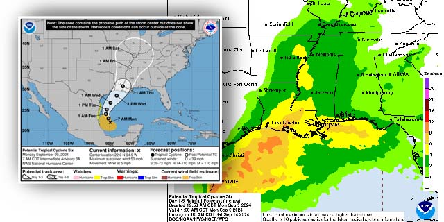
A tropical rainstorm formed in the Bay of Campeche late Saturday, and forecasters expect it to intensify as it tracks northward over the Gulf’s unusually warm waters. The system could bring heavy rain, strong winds, and potential flooding to the southern U.S., including Mississippi, this week.
As of Sunday, the tropical disturbance was located off the coast of Veracruz, Mexico.
Trending
Meteorologists predict it will reach tropical storm strength by Monday, with sustained winds over 39 mph. The warm waters of the Gulf, currently between 86-88°F, provide ideal conditions for the storm’s intensification.
AccuWeather experts warn that Mississippi could experience rounds of rain and thunderstorms beginning Tuesday, with the heaviest rainfall hitting the region between Wednesday and Thursday. Coastal areas may also face gusty winds and dangerous surf. Forecasters predict rainfall totals of 2-4 inches across the state, with flash flooding possible in areas already saturated from recent storms.
“This storm is concerning because it’s moving into an area that has already seen significant rain,” said AccuWeather Meteorologist Isaac Longley. “It won’t take much more to cause serious flooding.”
Wind gusts as high as 40 mph could reach southern Mississippi by midweek, and some areas may see even stronger gusts closer to the point of landfall. AccuWeather’s real-time monitoring system estimates potential wind gusts of 80-100 mph in coastal areas.
Residents are advised to stay informed and prepare for potential impacts. Coastal flooding, isolated tornadoes, and power outages are possible as the storm progresses. The storm surge is expected to range from 1-3 feet along the Gulf Coast.