Satellite images show extent of devastation from tornado that tore across Mississippi Delta
Published 1:48 pm Monday, March 27, 2023
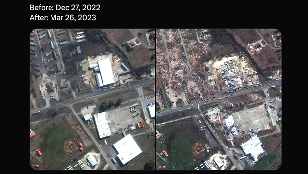
On Sunday, satellite images were released showing the extent of the devastation after a tornado tore across the Mississippi Delta landscape in Rolling Fork Friday night.
Maxar released the images of the town collected on Sunday and compared them to images collected in December 2022.
The images reveal the incredible damage to buildings, homes and infrastructure. At least 25 people were killed and dozens more injured after multiple tornadoes ripped through western Mississippi, officials said.
…..
New #satelliteimagery from today, March 26, of the aftermath of the powerful #tornado that struck #RollingFork, #Mississippi on Friday night.
Before: Dec 27, 2022
After: Mar 26, 2023 pic.twitter.com/dygvQGOiEl— Maxar Technologies (@Maxar) March 26, 2023
…..
Severe damage throughout the entire town of #RollingFork, #Mississippi, from the #tornado that hit on Friday, March 24. Seen here is the Walnut Street area.
Before: Dec 27, 2022
After: Mar 26, 2023 pic.twitter.com/QCj1DC9HO4— Maxar Technologies (@Maxar) March 26, 2023
…..
The tiny town of #RollingFork, #Mississippi lies in ruins from the March 24 #tornado. Seen here is the Walnut and Mulberry Streets area.
Before: Dec 27, 2022
After: Mar 26, 2023 pic.twitter.com/S3r4wljbd6— Maxar Technologies (@Maxar) March 26, 2023
…..
Destroyed homes and businesses seen here along the Blues Highway in #RollingFork, #Mississippi. The entire area has been declared a major disaster and federal aid has been ordered to assist in recovery efforts.
Before: Dec 27, 2022
After: Mar 26, 2023 pic.twitter.com/qKjMwBCy72— Maxar Technologies (@Maxar) March 26, 2023


